Summary
White House Location and Directions
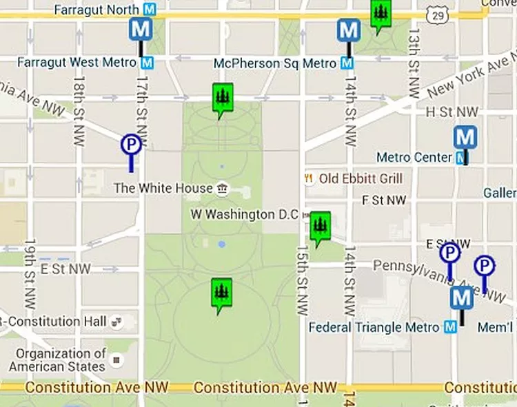
This map indicates the location of the White House and the surrounding area, with icons highlighting the closest metro stations and parking garages. The White House is situated northwest of the National Mall at 16th St. and Pennsylvania Ave, NW, Washington, DC. The Ellipse, located directly south, serves as a public park and is home to the National Christmas Tree. The White House Visitor Center is found in the Department of Commerce Building at the southeast corner of 15th and E Streets.
Getting to the White House
The area surrounding the White House is restricted from traffic for security purposes. Consequently, parking options are limited, and public transportation is recommended. The nearest Metro stations include Metro Center, Federal Triangle, Farragut West, and McPherson Square. Additionally, a Metrobus stop is conveniently located at the corner of Pennsylvania Avenue and 14th Street.
You can find a larger map and driving directions to the White House on the next page.
Parking Near the White House
The closest public parking garages to the White House are illustrated on the accompanying map. The Ronald Reagan Building and International Trade Center features an underground parking garage with 2,000 spaces, making it one of the best places to park in the area. There are two entrances available, accessible from Pennsylvania Avenue and 14th Street. All visitors and vehicles undergo screening upon entry. For additional details, explore parking options near the National Mall.
Things to Know About Visiting the White House
- Public tour requests should be submitted at least three weeks in advance through your Member of Congress.
- Tour participants gather at 15th and Hamilton Streets NW for grounds and building access.
- The nearest restrooms can be found in the Ellipse Visitor Pavilion (the park area south of the White House) and the White House Visitor Center.
- To take photos in front of the White House or participate in a public protest, visit the north side of the building facing Lafayette Park. The park is bordered by Jackson Place on the west, Madison Place on the east, and Pennsylvania Avenue.
Map of Washington DC and the White House

This map provides a larger view of the Downtown Washington DC area near the White House. Familiarize yourself with the location of many attractions within the area.
Driving Directions to the White House Visitor Center (1450 Pennsylvania Ave NW)
- From I-95 South – Take I-95 South toward Washington to I-495 East. Follow I-495 to Route 50 West. Bear right onto L Street. Turn left onto 7th Street, NW, and turn right on Constitution Avenue. Finally, turn right on 15th Street and follow it to Pennsylvania Avenue.
- From I-295/BW Parkway South – Take I-95 South to I-295 South Baltimore-Washington Parkway. I-295 South will split at Route 50, which becomes New York Avenue. Stay in the right lane and turn left on 7th Street. Turn right on Pennsylvania Avenue South to reach the intersection of 15th Street.
- From I-270 – Take I-270 South toward Washington to I-495 South toward Northern Virginia. Follow I-495 to the George Washington Memorial Parkway. Cross the Theodore Roosevelt Bridge, keeping to the right, and exit onto Constitution Avenue. Follow Constitution Avenue to 15th Street and turn left onto Pennsylvania Avenue.
- From I-95 North – Take I-95 North toward Washington. I-95 changes to I-395 once you cross I-495. Continue north on I-395. After crossing the bridge, exit onto US-1 North/14th Street. Follow US-1/14th Street to Constitution Avenue. Turn left on Constitution Avenue to 15th Street. Turn right onto 15th Street at Pennsylvania Avenue.
- From I-66 – Take I-66 across the Theodore Roosevelt Bridge, staying to the right, and exit onto Constitution Avenue. Proceed on Constitution Avenue to 15th Street and turn left. Follow 15th Street to the intersection of 15th and Pennsylvania Avenue.


