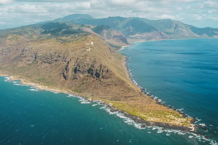
Summary of Oahu’s Leeward Coast Exploration
Oahu’s Leeward or Waianae Coast in Hawaii remains largely undiscovered by the vast majority of tourists to the island. This area is often overlooked, as it does not feature prominently in popular guidebooks. Consequently, many visitors may find the region seems too remote and appears uninviting.
In recent years, several beach parks have seen an increase in homeless individuals, including working families unable to find affordable housing.
Few tourists venture beyond Barber’s Point, Ko Olina, and Kapolei, let alone venture north to places like Waianae, Makaha, and Kaena Point.
Our exploration of the Leeward Coast begins at Yokohama Beach, at the northern end of Farrington Highway (Route 930), just south of Kaena Point.
The coastline here is rugged, with some of the oldest lava formations found along this shore. While the beaches are beautiful, the surf can be unpredictable. Therefore, caution is advised when swimming or surfing, especially during the winter months when waves can reach significantly higher heights compared to summer.
Makua Valley

Located just a short drive south of Yokohama Bay, the Makua Valley was once home to a thriving Hawaiian community before Western contact. Since the 1930s, part of the valley has been designated for military use, specifically for live-fire training exercises.
The valley is rich in biodiversity, hosting numerous endangered species of both plants and animals as well as sacred sites important to native Hawaiians. Tensions have arisen over the military’s use of land that holds cultural significance for the native population.
Renowned singer Robi Kahakalau describes Makua in a song as “the place where we Hawaiians can still be free.” Unfortunately, this autonomy is challenged by the military’s damaging presence.
Nearby, Makua Beach offers excellent swimming options during the calm summer months and served as a key filming location for the 1965 adaptation of James Michener’s novel Hawaii, featuring Julie Andrews and Max von Sydow.
Kaneana Cave

Just south of Makua, on the left, lies Kaneana Cave, named after Kane, the Hawaiian god of creation. According to legend, this cave symbolizes the womb of the earth goddess, from which humanity emerged to populate the Waianae Coast.
Historically, access to the cave was restricted, as it was believed to be the lair of Nanaue, the shark-man of Kaneana.
Spanning a hundred feet high and four hundred fifty feet deep, the cave is dark and damp. Therefore, a flashlight and suitable footwear are necessary for exploration.
Regrettably, the cave’s beauty and sacred status is marred by graffiti, and it lacks maintenance from government authorities.
Makaha Beach Park

Continuing along the Leeward Shore, we arrived at the stunning Makaha Beach Park, a 21-acre park boasting an expansive beach. The park, bordered to the west by Kepuhi Point, is renowned for its striking beauty.
During the winter months, waves can reach heights of up to 25 feet, crashing off Makaha Point and creating some of the most challenging surfing conditions on Oahu.
Though spring and summer bring milder conditions, winter’s high surf creates dangerous rip currents and strong backwashes.
Makaha Valley

Makaha Valley was once home to the Makaha Valley Ranch and has a rich history associated with Hawaii’s royalty. The Kane’aki Heiau, a restored temple dating back over 300 years, is also found in this valley and is devoted to Lono, the Hawaiian god of harvest and fertility.
Waianae and Pokai Bay

Traveling south from Makaha, we reached Waianae, the largest residential community on the Leeward Coast, home to the Waianae Small Boat Harbor, which serves as a departure point for several ocean tours.
We passed Pokai Bay, known for its calm waters, making it the most sheltered beach along the coast. The U.S. Army maintains a recreation center in this area, which was renamed in 2003 to honor Herbert Kaili Pililaau, a Medal of Honor recipient for his heroics in the Korean War. The Pililaau Army Recreation Center (PARC) offers excellent facilities for military personnel and their families.
At the bay’s southern tip, a coconut palm-dense peninsula known as Kaneilio Point is home to the three-tiered Kuilioloa Heiau.
Kolekole Pass

Upon reaching the town of Nanakuli, we turned off the highway, venturing inland towards the Waianae mountains. Most visitors typically navigate south around Kapolei for trips back to Waikiki or proceed through Central Oahu to reach the North Shore area.
However, if you or someone in your group holds valid military identification, you can traverse the U.S. Naval Magazine through the Kolekole Pass into Schofield Barracks, a U.S. Army base, and Wheeler Army Airfield. This restricted road allows military personnel and their dependents access most days until sunset.
The drive via Kolekole Pass offers breathtaking panoramic views of the Waianae Coast.
Utilizing this shortcut significantly reduces travel time, especially for those heading to the North Shore, as it brings you directly into Central Oahu, near Waiawa and Mililani.


