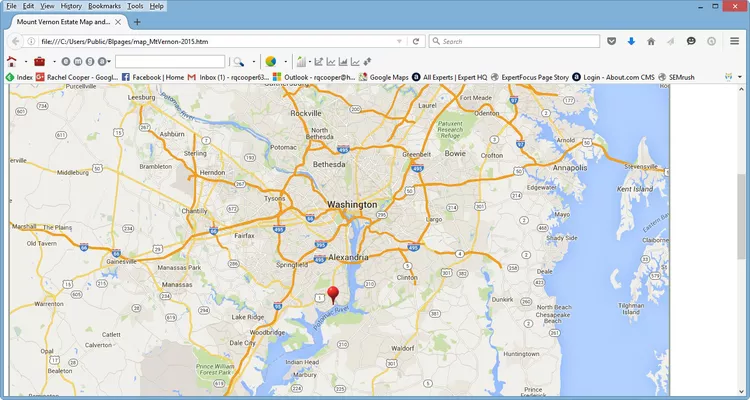
Summary of Visiting Mount Vernon Estate
This map shows the location of the Mount Vernon Estate, the home of George Washington, a popular historic site that attracts visitors from around the world. Mount Vernon is located along the Potomac River approximately 14 miles south of Washington DC. The historic site is a “must see” destination with a 14-room mansion, slave quarters, a coach house and stables, gardens, and a museum examining the life of America’s first president and his family. For sightseeing information, visit A Visitors Guide to Mount Vernon Estate and Gardens.
Transportation Options to Mount Vernon, VA
Mount Vernon is not directly accessible by Metro. However, you can take Metro to Huntington Station and easily transfer to the Fairfax Connector Bus #101 to Mount Vernon. Furthermore, you can conveniently combine your visit with an excursion to nearby Old Town, Alexandria. The historic town is a great place to explore with a wide range of restaurants, shops, museums, art galleries, and more. Notably, Alexandria is directly accessible by Metrorail with four convenient stations and connections to local bus services. Additionally, Mount Vernon is accessible by bike along the 18-mile Mount Vernon Trail, which begins at Theodore Roosevelt Island and runs parallel to the George Washington Memorial Parkway.
Driving Directions to Mount Vernon

The best way to travel to Mount Vernon Estate is by car, particularly via the George Washington Memorial Parkway, which offers scenic views of the Potomac River. There is ample parking available on-site at the estate.
Directions From Washington DC and Maryland:
Follow the George Washington Parkway South and continue past National Airport through Alexandria. The Parkway subsequently becomes Washington Street in Alexandria. Continue eight miles south of Alexandria. Mount Vernon Estate is located at the large traffic circle at the end of Parkway.
Directions From Virginia – South:
Take I-95, Exit 161, Route 1 North, Ft. Belvoir/Mt. Vernon. Continue north on Route 1 for about six miles through Ft. Belvoir. Then, turn right on Route 235 North. After three miles straight ahead, Mount Vernon will appear at a large traffic circle.
Directions From Virginia – West:
Take I-66 to I-495 South. Follow the outer beltway which transitions into I-95 North towards Baltimore. Take Exit 177B, Route 1 North, Alexandria/Mount Vernon. Turn right onto Franklin Street. Next, turn right again at Washington Street. Washington Street becomes the George Washington Parkway, and Mount Vernon is located eight miles south at the large traffic circle at the end of Parkway.
Closeup Map of George Washington’s Mount Vernon Estate

This map illustrates the layout of the Mount Vernon Estate and Gardens, including the location of the historic restaurant, the Mount Vernon Inn, the Ford Orientation Center, and the Donald W. Reynolds Museum. Parking lots are conveniently located on both sides of the circle just off of the George Washington Memorial Parkway. As reflected on the map, George Washington’s Mount Vernon, the mansion that was home to our first president and his family, faces the Potomac River. To discover more, consider reading about the importance of visiting Mount Vernon Estate and Gardens.
More About Northern Virginia
- Best Alexandria Restaurants
- Top 10 Northern Virginia Attractions
- A Guide to Northern Virginia Parks
- Maps of Northern Virginia


