Olympic National Park, renowned as one of the premier National Parks in the United States, offers visitors an exceptional retreat from the stresses of everyday life. Encompassing a temperate rainforest and providing an atmosphere of tranquility, it is an ideal destination for those seeking solace.
The Hoh River Trail is a standout option among the park’s many hiking routes. Situated on the western side of Olympic National Park, the journey begins at the main parking lot adjacent to the Hoh ranger station.
This comprehensive guide aims to equip you with all the necessary information to create an unforgettable adventure through this breathtaking ancient forest.
Accessing the Hoh River Trailhead
The trailhead is conveniently located about a 40-minute drive from Forks, Washington, a charming town well-known, albeit in a fictional context. For those traveling from Seattle or SeaTac airport, plan for a drive of approximately 3-4 hours. You may opt to navigate through Olympia to reach the western section of the park or choose to take the Edmonds-Kingston ferry. Regardless of the chosen route, expect a travel time of nearly 4 hours, especially given possible delays during the summer ferry season; for instance, on our April return trip, we encountered a wait time of 2 hours on a Sunday.
Hiking Considerations
The trail features minimal elevation changes for the initial stretch up to Lewis Meadow. However, past this point, expect to face a challenging ascent of over 4,000 feet leading to Glacier Meadows and the impressive glacier at the base of Mount Olympus.

Trail Distance
This trail offers flexibility in terms of length; reaching Lewis Meadow covers a distance of 10.5 miles one way, while the journey to Glacier Meadows extends to around 17.5 miles. The first 10.5 miles feature minimal elevation gain, but include three river crossings—two of which are located approximately a mile before the Olympic Guard station. Hikers should be prepared to remove shoes and navigate potentially slick rocks.
It is important to note that river conditions may fluctuate based on the time of year, occasionally rendering crossings impassable. Always verify current conditions with the ranger station prior to embarking on your hike.
Permits Required
A valid park pass is mandatory for entry, including the America the Beautiful pass, which is highly recommended for those planning to visit multiple national parks, monuments, or national forests within the year. If you intend to camp overnight along the trail, a wilderness permit is also necessary.
Wilderness permits are generally easy to obtain during the off-season, but availability becomes scarce during the summer months. All wilderness permits can be procured via the recreation.gov website, which also features a user-friendly app.
Optimal Visiting Period
For a tranquil experience, visiting during the off-season is ideal. With the right weather conditions, hikers can enjoy solitude along the trail. During our visit in April, we encountered only a handful of fellow hikers over two days, enjoying perfect weather.
The summer months draw larger crowds due to reduced rainfall, but it’s essential to remember that this region is a rainforest and rain is inevitable. Equip yourself with appropriate rain gear to fully embrace the experience, as the area is most stunning in varying weather conditions.
Weather Considerations
This region boasts the highest rainfall in the United States. Therefore, understanding the expected weather is crucial for planning your trek. Heavy rainfall can lead to swollen rivers, potentially complicating your crossings.
Water Availability
Thanks to the abundant rainfall, numerous water sources can be found throughout the trail. The Hoh River is a consistent presence, with several streams along the route. However, it is vital to carry proper filtration equipment, as appearances can be deceiving regarding water purity.
I recommend utilizing a comprehensive water filtration system, alongside items such as a Life Straw and CrazyCap, to ensure safe drinking water given the ample nearby sources.
Food Storage Guidelines
While bear canisters are not required in this area, hanging food bags is necessary. Most campsites along the route are equipped with bear wire, and appropriate signage is present. However, having a bear canister is always prudent, especially since we observed fresh black bear and cougar tracks during our hike, underscoring the importance of safely storing all scented items.
Navigational Aid
I always advise bringing a trail map. Although the path is well-marked, the possibility of losing your way is not entirely eliminated. During two river crossings, we encountered some difficulty regaining the trail, which was similarly experienced by other hikers we met. As cell service is nonexistent along this trail, a paper map is invaluable.
Camping Opportunities and Trail Highlights
Many hikers tackle the trail as a day hike, typically turning around after reaching a designated campsite such as Five Mile Island. Strong day-hikers might aim for the Olympus Guard Station, located approximately 9 miles in.

However, if you can spare at least one overnight stay, doing so will greatly enhance your experience in this area. Lewis Meadow serves as an excellent basecamp; on your first day, you can hike in to Lewis Meadow, set up your camp, and the following day explore Glacier Meadows before returning to camp for a second night. This progression offers an opportunity to fully appreciate the surroundings.

Conversely, Glacier Meadows is highly recommended for its scenic beauty. If you plan to ascend Mount Olympus, be sure to allocate at least one night there; keep in mind that winter conditions may necessitate spikes or crampons due to snow accumulation at higher elevations. Lewis Meadow, on the other hand, offers a more accessible location with moderate elevation changes and typically less snow.
Additional camping opportunities exist earlier along the trail, with options for group sites located prior to Lewis Meadow. The first campsite can be found at 2.5 miles in at Mount Tom Creek, boasting impressive views of its namesake. Continuing onward, at 5.3 miles, you’ll reach Five Mile Island and its campsites. Between Mount Tom and Five Mile Island, several noteworthy sites await, including the junction for Mount Tom trail, two stunning waterfalls, and the Cougar Creek cedar grove, home to centuries-old Sitka spruces.
After Five Mile Island, proceed for another 3.6 miles to the Olympus Guard station. Be mindful of the two river crossings nearby; they are closely situated. If you choose to remove your hiking boots for the first crossing—as recommended, especially given the chilly waters in April—consider wearing sandals for the following stretch.

Due to the relatively flat nature of the trail, it is feasible to hike portions while wearing sandals. We, in fact, made the trek from the river crossings to Lewis Meadow in flip-flops, though caution is warranted to avoid potential hazards along the path.
At Lewis Meadow, facilities include various campsites, a pit toilet, and bear wire for food storage. A group site is available, and walking towards the river allows for camping along the riverbank—or even on it—for a unique experience. Although this may necessitate a longer walk to the pit toilet and where you hang your food, the rewards are well worth the effort.

To reach Glacier Meadows, an additional 4.7 miles must be covered from the Olympus Guard station, making it essential to plan for an overnight stay if you wish to experience the glacier up close. In winter months, be sure to pack spikes or crampons, as snow is likely to obstruct the trail.
Alternative Trails
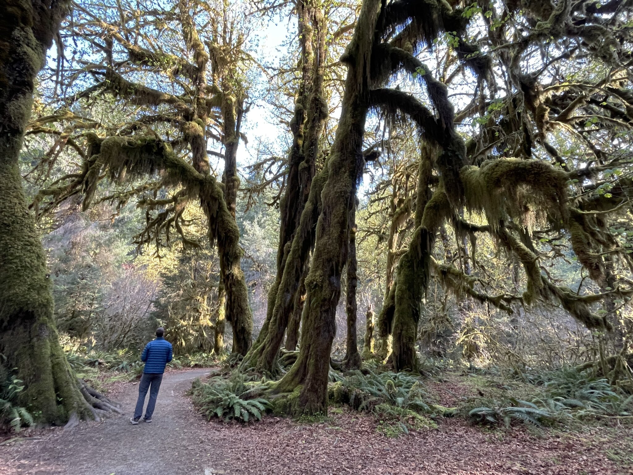
For those looking to appreciate the area’s beauty without extensive hiking, several shorter trails are available at the beginning of the Hoh River Trail. Notably, the Hall of Mosses trail is a renowned 0.8-mile loop that offers a flat and stunning route.

However, be mindful that summer months can lead to overcrowding, sometimes requiring visitors to wait for space along the trail. Given the fragile landscape, always remain on designated paths and observe Leave No Trace principles to safeguard the environment.
Another option is the Spruce Nature Trail, a 1.2-mile loop that provides a fantastic opportunity for wildlife viewing, particularly elk during the fall rutting season, when males may exhibit aggressive behavior.
Both trails, along with the Hoh River trail, showcase some of the oldest and largest tree specimens adorned with lush moss.
Shortly after passing the Olympic Guard station (0.8 miles in), a trail junction appears, directing hikers toward the Hoh Lake trail and the High Divide.

The iconic High Divide region, featuring exceptionally beautiful alpine lakes, can be accessed from Port Angeles as well as via this junction. To continue toward Lewis Meadow and Glacier Meadows, proceed right at this intersection.
Wildlife Observations
This area is rich in wildlife activity, with signage indicating the presence of cougars and black bears. It’s imperative that all visitors remain vigilant and practice precautions. In addition to these larger mammals, elk, black-tailed deer, and a diverse range of bird species can be spotted throughout the region. It was particularly thrilling to witness a hummingbird in its natural habitat for the first time.

Final Reflections
This trail represents an outstanding backpacking opportunity and has become my personal favorite among hikes on the Olympic Peninsula. The stunning vistas of the temperate rainforest set against the backdrop of rugged mountains create lasting memories for all who venture here.
It is important to note that this trail is not pet-friendly. For those who wish to explore the Olympic Peninsula with their canine companions, I suggest considering the National Forest or taking a journey to Marmot Pass.