Summary
Gunung Agung: A Bali Adventure
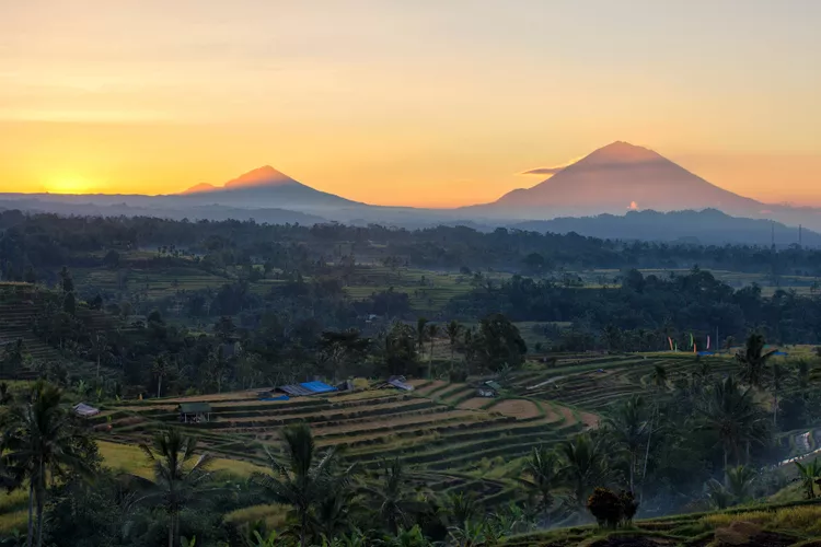
You might say Gunung (Mount) Agung isn’t just a mountain on Bali; Bali is an island that just happens to surround and depend on Gunung Agung. Either way, it’s difficult to overstate Gunung Agung’s significance to Bali and the Balinese.
At over 10,300 feet, the mountain influences the island’s climate by blocking the passage of airborne moisture from west to east. The terrain east of Gunung Agung is arid as a result.
For ordinary Balinese, Gunung Agung also happens to represent the central axis of the universe, the very summit of their three-tiered universe with the Gods at the top, humans in the middle, and demons below.

A Miracle on Gunung Agung
Gunung Agung itself is considered Bali’s most sacred point: every building points towards the summit, and every temple and altar faces the temple Pura Besakih on Gunung Agung’s slopes that stands as Bali’s most sacred temple.
As with the holiest-of-holies, the Balinese believe the temple is nothing short of miraculous.
Gunung Agung last erupted in February of 1963. According to Balinese superstition, this was due to an important once-a-century ceremony being performed incorrectly. Over 1,500 lives were lost in the wake of the initial eruption, with even more fatalities occurring during a secondary eruption later in the year. The eruption also blew off the top 400 feet of the mountain and caused more vivid-than-usual sunsets as far away as Europe and the Americas.
Miraculously, Pura Besakih remained unharmed throughout this violent eruption. Locals claimed that the lava flow came alarmingly close to the temple—within mere yards—but left the temple itself undamaged.

Climbing Gunung Agung
With a midnight start and an arduous 7-hour uphill trek, climbers intending to ascend Gunung Agung should consider the experience to be more than just a casual stroll. Among Indonesia’s volcanoes, Gunung Agung ranks among the more challenging excursions.
Another volcano worth climbing on Bali is Mount Batur in Kintamani, whose two-hour trek pales in comparison to the difficulty of Gunung Agung’s ascent.
Many trekkers prefer to stay in the quiet East Bali town of Sidemen, which offers a good variety of accommodations close to the trail.
If shorter treks are more appealing to you, consider staying in Selat, which will cut approximately 15-20 minutes off your trek.
Gunung Agung is located in the Karangasem district of East Bali, about an hour from Ubud, Bali’s cultural center. Numerous travel agencies in Ubud provide transportation to Pura Besakih, and your accommodation can arrange for a private driver should you prefer to visit Gunung Agung independently.
Alternatively, you can drive south for one hour from the Kintamani region toward Rendang to access Gunung Agung.

Gunung Agung’s Two Climbing Routes
Tourists can choose between two primary routes to ascend Gunung Agung.
The challenging Besakih approach originates about half a mile from the Pura Besakih temple and leads to the western peak, reaching an elevation of 9,944 feet. Although this route is more demanding, it rewards climbers with breathtaking views of Bali.
The easier (but still demanding) route starts at Pura Pasar Agung, the highest temple in Bali, and ends at the rim of the crater, just 300 feet below the absolute summit, providing panoramic vistas of southern and eastern Bali.
Additionally, during the dry season, climbers can begin on the second route and switch to the first midway, thanks to a connecting path that opens up.
Time your ascent well, and you will be welcomed by an unforgettable sunrise and stunning views that encompass much of Bali—on clear days, you may even catch a glimpse of Lombok’s Gunung Rinjani! Nevertheless, aim to descend before 9 AM, as clouds typically start rolling in.
Be aware that both routes may be closed during high holy days, so checking with locals beforehand can ensure a smooth climbing experience.

Gunung Agung Climbing Must-Haves
No special climbing gear is necessary to reach the summit of Gunung Agung. However, the unpredictable weather and challenging conditions necessitate prudent preparation. Bring the following essential items:
- Cold Weather Jacket: The morning temperatures can be quite chilly, and the exposed summit is often windy.
- Waterproof Gear: Given Gunung Agung’s impact on Bali’s climate, be ready for unexpected rain, even during dry months.
- Sun Protection: The sun can be intense after a chilly wait for sunrise. Be sure to carry a hat and sunscreen to protect yourself. For tips on sun care, read about how to protect yourself from sunburn in Southeast Asia.
- Proper Shoes: Given the volcanic rock, sandals and exposed toes are inadvisable. Wear sturdy closed-toe climbing shoes for better grip on slippery mud and rocky paths.
- Water: Bring at least two liters, as no water points exist along the climb.
- Food and Snacks: The food near Pura Besakih is often overpriced and subpar. Therefore, having your own high-energy snacks will help refuel your energy during the climb.
- Flashlight: Navigating the trail before dawn requires good visibility. A headlamp will keep your hands free for climbing.
While guides are required, their enforcement is often lax, but for your safety, hiring a guide is advisable. You can arrange for guides at either Besakih or Pura Pasar Agung, though securing one in advance is preferable; both Sidemen and Selat towns offer guide services for Gunung Agung.
Expect to pay around $50-$80 for a guide, typically including breakfast at the summit, usually a light pancake meal.
When to Go
The ideal time for climbing Gunung Agung is during Bali’s dry season between April and October. In contrast, the wet months from November to March can make paths slippery, posing risks of mudslides.


