Summary
California Road Map of the Highway System
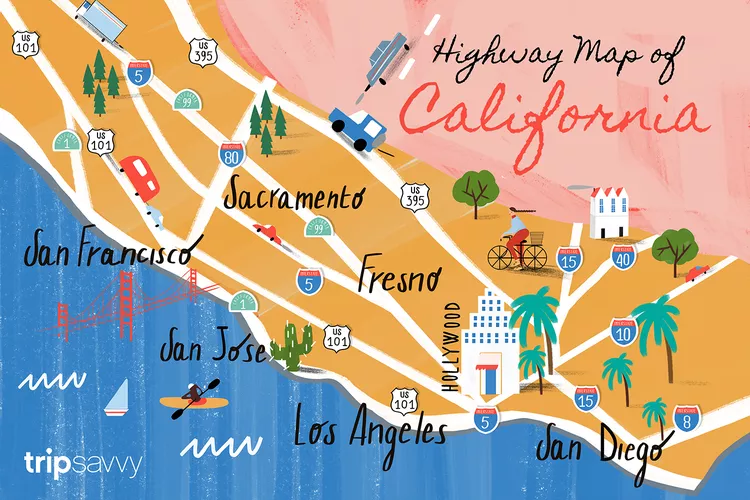
At first glance, you might wonder why this California road map is different from any of a thousand others that appear when you search for “California road map” or “California highway map.”
Here’s the answer to that burning question: This map highlights the basics and the larger cities, but it leaves out all the clutter that can show up on interactive maps. It provides an overview of the highway system, with the most commonly used routes highlighted. At a glance, you can determine that Highway 99 goes to Fresno or find all the highways that lead to Los Angeles.
In other words, it’s custom-made for visitors and vacationers.
It’s the essential map you need when planning your trip, but it’s not the only tool available. While it can’t provide driving directions or distances, it’s an easy way to get a better understanding of what’s where and how to navigate between the major cities.
What You Need Besides a California Highway Map
If you require detailed driving directions, an app like Google Maps or Apple Maps is typically the best option.
However, they often struggle to differentiate between slow or stopped traffic and longer-lasting road closures. You might get a hint from a highway speed map with a gap, but even then, you can’t determine whether they’re dealing with a rogue giraffe or repairing a section of missing pavement the size of Rhode Island.
Road closures can occur for construction, but in California, you also need to know about winter snow closures and roads that close during winter rains due to mudslides. Occasionally, a wildfire might cause a road closure as well.
CalTrans, the state’s highway department, is your go-to for the most accurate, detailed information. They offer a mobile Quick App, but their website is more helpful if you need updates on significant road closures.
Before you travel, simply enter the highway number you want to check by using the Cal Trans website. It will provide information about temporary closures and ongoing road work. Their site can also help you find out if roads through the mountain passes are closed due to snow or if landslides have affected coastal highways.
Getting Around in California

If you’re seeking more than just driving information, you can save yourself hours of research as it’s already done for you. Whether you want to travel from San Diego to Los Angeles by air, train, bus, or car, there are numerous options available.
You might also need to know how to navigate the Disneyland Resort or find out how to travel around Lake Tahoe. In San Diego, it’s helpful to understand how you can get from place to place using the San Diego Trolley.
Driving in California

If you’re planning a trip to the mountains during winter, it’s vital to know when snow chains are required for driving in California.
Moreover, you may also need to navigate through the major tourist areas in California. If your plans include visiting LA, having an understanding of local traffic lingo and other transit tips is essential. The unique transportation system in San Francisco, with its mix of buses, trolleys, and cable cars, can also be puzzling.
For visitors unfamiliar with California’s traffic rules, a comprehensive overview is available in the California driving survival guide. This resource summarizes the laws you need to know while also addressing the cultural nuances that may confuse newcomers.


