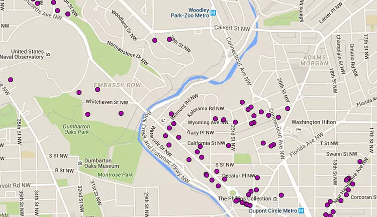
Embassy Row in Washington DC represents a significant area where numerous foreign embassies are established, notably along Massachusetts Avenue, stretching from Dupont Circle towards the National Cathedral. In total, Washington, DC boasts over 175 foreign embassies, residences, chanceries, and diplomatic missions, yet less than half are situated directly along Embassy Row. A notable concentration of embassies can also be found along a four-block stretch of New Hampshire Avenue adjacent to Dupont Circle, with another cluster closer to Connecticut Avenue.
Embassies Along Embassy Row
The embassies marked on this map with a purple circle include: Philippines, Peru, Trinidad and Tobago, Chile, Uzbekistan, Portugal, Indonesia, Luxembourg, Togo, Sudan, Bahamas, Ireland, Romania, Cyprus, Guatemala, Armenia, Latvia, Burkina Faso, Kyrgyzstan, Madagascar, Paraguay, Malawi, Ivory Coast, Korea, Japan, Brazil, Bolivia, and the United Kingdom. For an alphabetical guide to all embassies, consider referring to the Washington, DC Embassy Guide.
Getting to Embassy Row
Embassy Row is conveniently located in Northwest Washington DC, easily accessible within walking distance of the Dupont Circle and Woodley Park Zoo Metro Stations. It lies just south of the United States Naval Observatory and north of Dumbarton Oaks Museum and Park. Most embassies are concentrated between Connecticut Avenue and Massachusetts Avenue, east of Rock Creek and the Potomac Parkway NW.
It is important to note that the Embassy Row area experiences significant foot traffic, making parking quite limited. Therefore, utilizing public transportation is highly recommended. While some street parking exists, it can be challenging to find available spaces.
Another option is to use Capital Bikeshare, which enables you to rent a bike from one of over 180 stations in DC and Arlington, returning it to a nearby docking station. The nearest docking stations are located at 34th St & Wisconsin Ave NW and 36th & Calvert St NW.
Driving Directions:
- From the North: Take I-495 West to Silver Spring, exit at 33 for Connecticut Avenue South (Route 185), and continue on Connecticut Avenue for about 8 miles. Embassy Row will be on your right before reaching Dupont Circle.
- From the East: Take Route 50 East (New York Avenue); after it becomes Massachusetts Avenue, proceed to Thomas Circle, stay in the middle lane, and continue to Dupont Circle. Navigate the circle heading northwest on Massachusetts Avenue.
- From the South: Take I-395 North to US 1, continuing to the 14th Street Bridge. Follow the same route via Thomas Circle to Dupont Circle and then head northwest on Massachusetts Avenue.
For a more comprehensive view, consider accessing a larger map.
Larger View of Embassy Row Map

This map provides an extensive view of Washington DC, including the notable location of Embassy Row. This area is home to many foreign embassies, residences, chanceries, and diplomatic missions, highlighting the rich international presence in the city. A walking tour through the region is highly enjoyable, offering a glimpse into the diverse architectural styles of these buildings, which are both varied and intriguing. Additionally, Embassy Row features a range of small museums, perfect for exploration and learning about various subjects, from modern art to political memorabilia.


