Summary
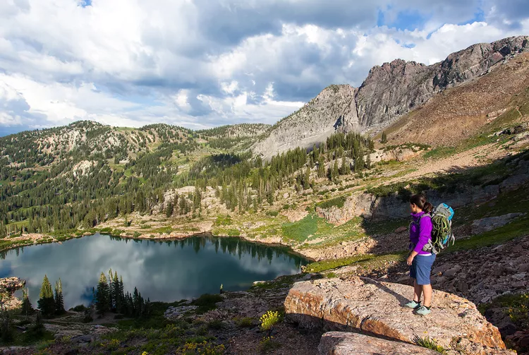
The Cecret Lake trail is one of the most beautiful, fun, and rewarding easy hikes in the Salt Lake area. Offering plenty to see and do for visitors of all ages, Cecret Lake is a great day trip for the family on your vacation to Utah.
Cecret Lake, also spelled Secret Lake, is located near the town of Alta in the Albion Basin, which is famous for wildflowers that bloom mid-July through August. The trail is 1.2 miles each way and gains about 450 feet in elevation. It’s easy enough for almost everyone, but children find it enough of a challenge that they will feel a sense of accomplishment when they reach the lake.
To get to the trail, drive up the main road of Little Cottonwood Canyon, past Alta ski resort to Albion Basin Campground. The road turns to gravel once you get past the ski resort, but it’s suitable for two-wheel drive cars, and there’s a small parking lot at the trailhead.
What to Expect
Hiking to Cecret Lake is a memorable outing, especially during wildflower season or in early October when the leaves have changed color.
The trail crosses a footbridge over Little Cottonwood Creek and continues through spectacular wildflower meadows and up a rocky slope to the picturesque lake. You’ll need to follow the signs to avoid confusing spur trails, and along the way, there are numerous signs with information about the wildlife and geology of the basin if you want to learn more about the area.
Once you’ve arrived at Cecret Lake, you might witness a moose family drinking from the lake. Although you may be tempted to dive into the pristine waters, swimming is strictly prohibited. After you’ve explored the area, more ambitious hikers can continue to the top of Sugarloaf Peak or return the way you came back to the parking lot.
Location and More
The Cecret Lake Hiking Trail and Cecret Lake are located in the Wasatch National Forest about halfway between the Albion Basin Campground and the peak of Sugarloaf Mountain. The trails leading between all three of these popular destinations are about three and a half miles long and takes approximately one and a half hours to hike at a steady pace.
Although it’s only about 33 miles southeast of Salt Lake City, it takes about an hour to reach the trailhead from downtown. Remember to drive carefully and obey the speed limit on the winding roads in the mountains to ensure you arrive safely—sharp curves are common in this area of Utah.
Rarely, during the busiest times of the tourist season, the parking lot at the trailhead may become too full, and you may not be able to drive all the way to Albion Campground. If this happens, you can walk up the dirt road from the Alta parking lot to the trailhead. On weekends and holidays during the summer, the town of Alta provides a shuttle from Alta’s Albion Base parking lot to the trailhead.


