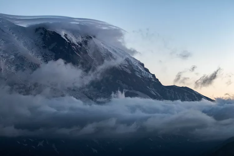
Discover Mt. Rainier Near Seattle
Spend any sunny day in Seattle, and you’ll notice a towering, snow-capped mountain rising over the horizon. Mt. Rainier is an iconic sight for visitors and a cherished landmark for residents who relish its visibility. (Local lingo pro tip: “The mountain” refers to Mt. Rainier, and saying the mountain is “out” indicates clear weather.)
This majestic mountain makes for an easy day trip from either Seattle or Tacoma, standing as one of the national parks closest to Seattle. The prominence of Mt. Rainier has made it a symbol of the region—visible on various souvenirs and local paraphernalia, it also serves as a navigational landmark.
Best Views From Seattle
As long as there aren’t low clouds, you can spot Mt. Rainier from numerous locations across Seattle. Often, you’ll catch sight of the mountain while driving on I-5 or strolling through a park.
Some of the prime viewing spots combine the mountain with other stunning Northwest landscapes. Walk along the shoreline at Discovery Park for a remarkable scene featuring water, shoreline, and Mt. Rainier in the background. Furthermore, getting onto the water, such as taking a ferry to Bainbridge Island or Bremerton, offers an exceptional vantage point for capturing the Northwest’s beauty. You may also take an ascent to the Space Needle, Columbia Tower, or Smith Tower for an elevated view of both the mountain and the surrounding cityscape.
Moreover, Mt. Rainier is visible from other Western Washington cities including Everett and down to Olympia, the state capital. Depending on your location, you may even glimpse additional major peaks in the region, including Mt. Adams to the south, the Cascades to the east, and the Olympics to the west.
How to Visit
The mountain is situated approximately two hours south of Seattle, and there are several ways to experience it.
- Drive: A road trip is ideal for those traveling independently. Simply take I-5 south from Seattle, and you can either branch off onto 405, then 167, leading directly to Meridian, which takes you out to the national park. Alternatively, proceed along I-5 directly to Tacoma and transition to State Route 7 (Pacific Avenue). Both routes take roughly the same amount of time; however, the Pacific Avenue route is slightly longer. These routes will guide you to different sides of the national park where Mt. Rainier resides.
- Join a tour: If you prefer not to drive, consider joining a guided tour from Seattle. Various companies provide such day tours, typically lasting around 10 hours, with stops at scenic points, including Paradise or Longmire visitor centers, and noteworthy sites like Christine Falls and Reflection Lake.
- Fly: You also have the option of flying. Kenmore Air offers small plane air tours that not only circle Mt. Rainier but also highlight Mt. St. Helens, providing a breathtaking aerial perspective of these magnificent landscapes.
History and Facts
Mt. Rainier is steeped in history and has been known by various names. The Puyallup people referred to it as Tacoma, Tacobeh, or Tahoma. These names have considerably influenced the modern city of Tacoma, which is located just an hour from the park entrance. The mountain was named Mt. Rainier by George Vancouver in honor of his friend, Rear Admiral Peter Rainier. It wasn’t until 1890 that the U.S. Board of Geographic Names officially recognized the name Mt. Rainier, though references to both its official title and its native names persist.
Standing at a height of 14,411 feet, Mt. Rainier is not only a prominent volcano but also one of several in the vicinity, including Mt. St. Helens and Mt. Adams to the south, as well as Mt. Baker to the north. However, Mt. Rainier is considered the most hazardous of the bunch. Should it erupt, it could trigger lahars (massive mudslides) affecting surrounding valleys, leading to potentially catastrophic damage. As a result, it has earned its status as one of the world’s 16 Decade Volcanoes, categorizing it among the most dangerous volcanoes globally, alongside Mauna Loa in Hawaii.
The mountain’s appearance varies between Seattle and Tacoma. From Tacoma, the crater is more prominent, whereas in Seattle, the summit appears more rounded, and one can also see a minor peak on the side.
Furthermore, Mt. Rainier serves as the source for several rivers flowing through Seattle, Tacoma, and other surrounding cities, including the Puyallup River, which empties into Commencement Bay in Tacoma.


