Summary
Location of the Pentagon
The Pentagon is strategically situated off of I-395 on the Virginia side of the Potomac River. It lies just east of Arlington National Cemetery and northwest of Ronald Reagan National Airport. The most efficient way to reach the Pentagon is via Metrorail. It is important to note that there is no public parking at the Pentagon. Visitors can utilize parking at the Pentagon City Mall (The Fashion Center at Pentagon City) and conveniently walk to the entrance through a pedestrian tunnel. For detailed information on visiting the Pentagon, refer to Pentagon Tours – Reservations, Parking and Visiting Tips. The shopping mall, located at 1100 South Hayes Street, Arlington, VA, features a vast array of retail stores and dining options.
Getting to the Pentagon City Mall
By Car – The Pentagon City area is easily accessible via the George Washington Memorial Parkway, I-395, and US Route 1.
Directions from Downtown, DC to Pentagon City Mall:
- Take I-395 South toward Richmond.
- Take Exit 8C on the left to merge onto U.S. 1 South toward Pentagon City/Crystal City/Alexandria.
- Take the 15th St S exit toward Pentagon City.
- Turn right onto 15th St S.
- Turn right onto S Hayes St.
- Turn left onto 12th St S.
- Turn right and the Mall will be on the left.
Directions from the George Washington Memorial Parkway South:
- Exit toward I-395 N/Lyndon B. Johnson/Memorial Grove/Pentagon.
- Keep right at the fork, follow signs for Interstate 395 S, and merge onto S Washington Blvd.
- Merge right onto VA-244 W/Columbia Pike toward Virginia 27/Navy Annex/Wash Boulevard.
- Turn left onto S Joyce St.
- Turn left onto Army Navy Dr.
- Turn right.
Parking is accessible from South Hayes Street, with hourly rates applicable on weekdays. Fortunately, parking is free on Saturdays and Sundays.
By Metro: The Pentagon City Metro Station is conveniently located within the Fashion Center at Pentagon City at 1250 South Hayes St, Arlington, VA. Refer to a guide for Using the Washington Metrorail.
By Bus: Multiple Metrobus services including 7AFY, 13Y, and 16ABDEJP operate with stops outside of Pentagon City Mall, along with ART (Arlington Transit).
By Bicycle: Another eco-friendly option to reach Crystal City is through Capital BikeShare. This bike-sharing program allows you to rent and return a bike at any of the 110 stations located throughout Washington, DC, and Arlington, VA. Kiosks are conveniently situated at 12th & Hayes St. and at the Pentagon.
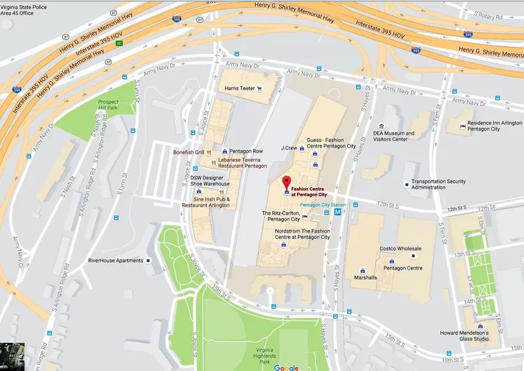
Pentagon City Map

Pentagon City is situated south of I-395, just across the 14th Street Bridge from Washington, DC. The Fashion Centre at Pentagon City serves as the primary attraction in this area. Main streets surrounding the shopping mall include Army Navy Drive and S. Hayes St. The mall provides public parking for approximately 4000 vehicles. Visitors to the Pentagon and the Pentagon Memorial must use this parking facility and proceed through a pedestrian tunnel to the entrance. For further information on visiting the Pentagon, refer to Pentagon Tours – Reservations, Parking and Visiting Tips.
Pentagon City Mall Store Map

This map highlights the prominent stores and restaurants within the Pentagon City Mall. This premier shopping destination is located in Arlington, VA, and is easily accessible due to its own Metro Station, making it a convenient location for visitors from Washington DC.


