Summary
The Blue Lakes Trail in Colorado is one of the most beautiful day hikes you can experience. This moderately challenging hike leads you to stunning alpine lakes renowned for their turquoise waters, alongside mesmerizing mountain vistas.
This trail can be comfortably accessed as a day trip from nearby towns like Ridgway, Ouray, or Telluride, making it an excellent choice for outdoor enthusiasts. In this guide, you will learn all the details about the Blue Lakes hike, covering the trailhead to the upper lake.
Quick Facts
- Distance: 7 – 11 miles (10 – 18 km) round trip
- Elevation: 9,350 – 13,000 feet (2,850 – 3,950 m)
- Elevation Gain: 1,600 – 3,650 feet (500 – 1,100 m)
- Duration: 3 – 8 hours round trip
- Difficulty: Moderate / Hard
Blue Lakes Trail: What To Expect
The Blue Lakes Trail encompasses three picturesque lakes and a breathtaking mountain pass. While most hikers opt to visit only the lower blue lake, there are two additional lakes waiting to be explored.
This trail is particularly popular among day hikers and backpackers; therefore, it’s advisable to visit on weekdays to avoid large crowds. The lower blue lake often fills up with campers during summer weekends.
The hike’s difficulty varies depending on the distance you choose to cover. The trek to the first lake is relatively moderate, and it is also suitable for dogs. However, if you plan to visit the second and third lakes, be prepared for a more strenuous climb. Always remember to carry ample water and snacks during your hike.
• Trailhead To Lower Blue Lake Colorado (Part 1 of 4)
Distance: 3.5 miles
Elevation Gain: 1,600 feet
Time: 1.5 – 2 hours
The trail begins with a gradual ascent through lush pine forests and meadows, accompanied by distant mountain scenes.
After about an hour, the landscape begins to unfold, and a lovely waterfall appears just before reaching the first lake.
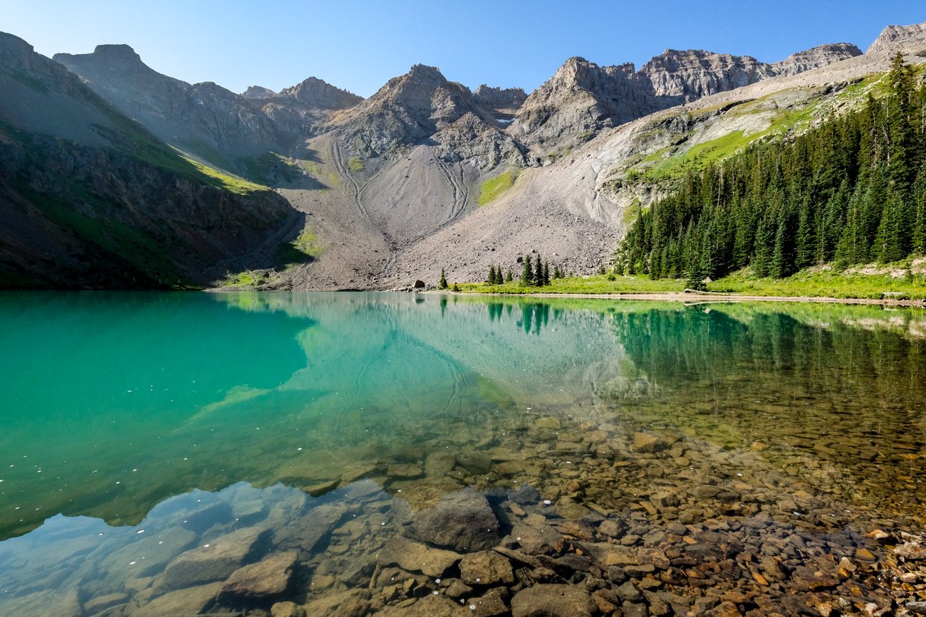
Lower blue lake is a sight to behold, with its crystal-clear turquoise waters framed by towering peaks—it truly exemplifies the beauty of Colorado’s lakes!
Spend some time exploring the lake’s shoreline; the vibrant hues are unmatched, especially when sunlight strikes the water. Early morning or overcast conditions can dull the lake’s brightness, so plan your visit accordingly.
• Lower Blue Lake To Middle Blue Lake (Part 2 of 4)
Distance: 0.7 miles
Elevation Gain: 650 feet
Time: 30 – 45 minutes
After enjoying the lower blue lake, it’s time to ascend to the middle lake! Return to the junction sign and take a left to start this segment.
Cross a small creek using rocks and logs, and follow the unmarked path leading up the rocky basin. Numerous trails converge towards the same destination, making navigation straightforward.
The incline to the second lake is steeper, but the panoramic views of the first lake and vibrant wildflowers make the effort worthwhile.
Although the middle lake lacks the striking turquoise color, its changing shades from green to dark blue offer a different and equally beautiful experience.
• Middle Blue Lake To Upper Blue Lake (Part 3 of 4)
Distance: 0.3 miles
Elevation Gain: 150 feet
Time: 15 minutes
The journey from the middle lake to the upper lake is straight and typically takes under 15 minutes.
The upper lake, while less vibrant in color, boasts crystal-clear waters and fewer visitors than the lower lake, providing a serene escape.
• Upper Blue Lake To Blue Lakes Pass (Part 4 of 4)
Distance: 1.5 miles
Elevation Gain: 1,250 feet
Time: 1 hour +
After reaching the upper lake, take the path along the north side to ascend towards blue lakes pass.
This final section includes steep switchbacks, requiring some effort, but it rewards you with view of the entire blue lake trail and Yankee Boy Basin.
The trek from the trailhead to the pass is roughly 6 miles with 3,650 feet of elevation gain. Once at the top, you can choose to retrace your steps or venture up Mount Sneffels for a challenging climb.
Trailhead For Blue Lakes: How To Get There
The main Blue Lake trailhead is conveniently located near Ridgway, Colorado. Here are directions to help you reach it:
- Main Blue Lake Trailhead: 38.02200152751049, -107.81835071502937
- Alternate Blue Lake Trailhead: 37.99592041602135, -107.78459542282823
For the best experience, consider basing yourself in Ridgway, Ouray, or Telluride. The northern trailhead is roughly a 45-minute drive from Ridgway, 1 hour from Ouray, or 1.5 hours from Telluride.
Alternatively, you can start from the southern trailhead in Yankee Boy Basin, though many find this route less convenient for accessing the popular Lower Blue Lake.
Trailhead Conditions
The route to the Blue Lake trailhead is generally well-maintained, suitable for all vehicle types during summer. However, the last few miles may be bumpy, so higher clearance vehicles are advantageous to navigate around potholes.
Facilities at the trailhead include a vault toilet, information signs, and a trail map. Always practice responsible hiking by preserving the environment and respecting fellow hikers.
Where To Stay


Camping At The Blue Lakes
Camping and fishing opportunities abound here, particularly at lower blue lake, which is known for cutthroat trout.
While there are excellent camping spots available, weekends can lead to crowded conditions. Always pack out what you bring in and leave the area at least as clean as you found it. Enjoy your outdoor adventures!


