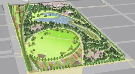
In early December of 2009, MAPS 3 was approved by Oklahoma City voters. This extensive plan, which encompasses a variety of projects, including a new streetcar line, a convention center, and improved sidewalks, is set to significantly transform the city’s landscape, just as the original MAPS initiative did. One of the most prominent aspects will be a 70-acre central park that will create a vital link between downtown and the Oklahoma River area.
MAPS 3 Downtown Park Facts
Designers: Hargreaves Associates
Location: The park will consist of two sections connected by the SkyDance Bridge over I-40. The upper section will be located between Hudson and Robinson, extending from the interstate up to the future Oklahoma City Boulevard, integrating the historic Union Station building at SW 7th. The lower section will extend west to Walker on the northern area and reach as far south as SW 15th.
Size: 70 acres, comprising 40 acres for the upper and 30 acres for the lower section
Estimated Cost: $132 million
Estimated Completion: 2020-21
MAPS 3 Downtown Park FAQs
What will the park look like? In 2012, the city engaged with residents to determine their desires for the MAPS 3 park. After analyzing survey feedback, Hargreaves Associates provided three conceptual designs, further inviting public input. By 2013, a definitive park master plan was presented.
While the specifics are still being finalized, the plan envisions a spacious grand lawn on the northern side of the upper section, along with a large lake at its center. A cafe will be situated just north of the stage on the grand lawn, with play areas positioned between the lake and the lawn. The lower section will feature sports fields in both the northern and southern areas, while the central part will include wetland gardens and a dedicated dog run.
You can view the complete presentation of the master plan for more insights.
What other features will be included? If all aspects come to fruition, the park will cater to a range of activities. Visitors may stroll through woodlands or across prairies, play soccer, relax in shaded areas, or admire the gardens’ beauty. The lake will support paddle boats, and the expansive lawn is designed for large outdoor events, with a capacity for approximately 20,000 attendees, making it ideal for concerts or movie screenings.
Will the streetcar pass by the park? Although the streetcar will not pass directly by the park, it will be conveniently close. The current recommended MAPS 3 streetcar route travels along Reno west to Hudson, requiring only a short walk to reach the park. Future expansions may extend the streetcar further south along Hudson.
How will OKC pay for the park upkeep? The funding for construction arises from MAPS 3 sales tax collections; however, ongoing park operations will need separate financial resources. Some expenses may be offset by revenue generated from the cafe or large events, and it has been suggested that a non-profit organization be established to oversee park management. Numerous details are still pending resolution.
What about the buildings that are there now? As previously mentioned, the plan includes retaining the Union Station building and integrating it into the park, potentially for use as park offices or an event venue. Currently, other buildings on the site are slated for demolition. Nevertheless, efforts are underway to preserve additional historic structures, such as the nearly 90-year-old Film Exchange Building located at SW 5th and Robinson.
How long before the park is being constructed? The park’s development is organized into three phases. The first phase, which involves land acquisition and design, is already in progress. Major construction activities are expected to begin during phase two, likely around 2017, with the lower section being the final segment to complete the project.


