Summary
- 1. Formation of Lake Tahoe
- 2. Driving Around Lake Tahoe
- 3. Getting to Lake Tahoe
- 4. Lake Tahoe Tours and Activities
- 5. Incline Village to Tahoe City
- 6. Tahoe City to Emerald Bay
- 7. Emerald Bay to Stateline
- 8. Spooner Junction to Carson City or Return to Reno
- 9. Lake Tahoe Nevada State Park
- 10. Lake Tahoe by the Numbers
Lake Tahoe is not an ancient volcanic caldera like Crater Lake. It was formed by the movement of fault blocks. In addition to fractures in the Earth’s crust, today’s Lake Tahoe Basin was shaped by glaciers and is enclosed by the Sierra Nevada to its west and the Carson Range to its east.
Politically speaking, Lake Tahoe is situated in both Nevada and California, with approximately one third within Nevada (east shore and half the north shore). Washoe, Carson City, and Douglas Counties encompass the Nevada portion. From Reno and Sparks, access to the north shore at Incline Village is via the Mt. Rose Highway (Nevada 431).
Forests in the Lake Tahoe Basin once faced extensive clear-cutting during the Comstock mining boom. From its initial discovery in 1859 until the slowdown towards the end of the century, timber was harvested rapidly to support the mines. Thankfully, after halting the destruction, the forest has successfully regenerated to what we see today.
Driving Around Lake Tahoe
Consider driving around the Lake as a leisurely tour. The route consists of narrow, winding mountain roads, steep drop-offs, and considerable traffic during the summer tourist season. However, there are plenty of stops to enjoy breathtaking views, take a leisurely hike, or have a picnic. Much of the shoreline is publicly accessible, with parks, beaches, swimming areas, and other attractions. The circuit spans 72 miles and typically takes about three hours of pure driving. Since most visitors will want to stop and explore, it is advisable to allocate an entire day to fully appreciate this remarkable location.
Getting to Lake Tahoe
There are five main routes into Lake Tahoe. Kick off the journey by taking the Mt. Rose Highway (Nevada 431) from its intersection with S. Virginia Street (near the Summit Sierra mall) up to Incline Village, covering roughly 35 miles from Reno.
Lake Tahoe Tours and Activities
Exploring the Lake Tahoe area becomes even more exciting with engaging activities. Here are some tours and experiences that will make your Lake Tahoe visit unforgettable:
Lake Tahoe Helicopter Tours
Lake Tahoe Water Sports
- Power Boat Rentals at Lake Tahoe
- Lake Tahoe Jet Ski Rentals
- Lake Tahoe Pontoon Boat Rentals
- 1 to 2-Person Canoe and Kayak Rentals at Lake Tahoe
- Lake Tahoe Parasailing Rides
- Lake Tahoe Emerald Bay Cruise on M.S. Dixie II
Winter Fun at Lake Tahoe
Incline Village to Tahoe City
Upon reaching the intersection in Incline Village, turn right onto highway 28. After crossing the state line at Crystal Bay, you will enter Kings Beach, CA, and continue through Tahoe Vista and Carnelian Bay until you reach Tahoe City. This drive covers about 15 miles and is developed with private shorelines, although public access to the water can be found at spots like Kings Beach Recreation Area. For alternative routes, U.S. 89 from Tahoe City leads north to Squaw Valley, Truckee, and I80. California 267 from Kings Beach also takes you to Truckee.
Tahoe City to Emerald Bay
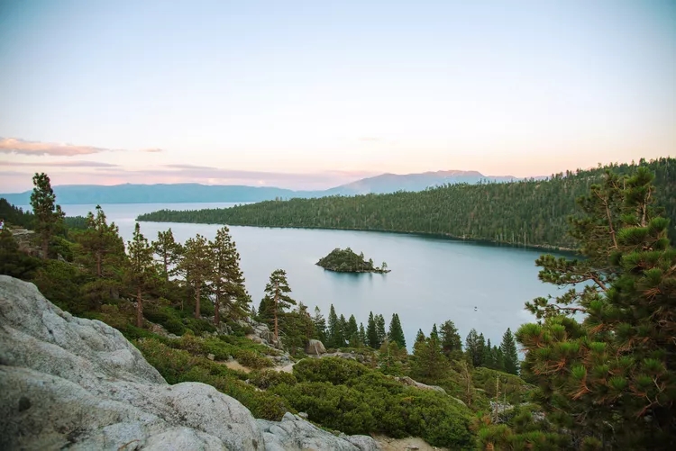
Proceed south from Tahoe City for 18 miles to reach Emerald Bay. Along the way, you will pass through Homewood, Tahoma, and Meeks Bay. As you near Emerald Bay, the road turns more serpentine and hugs the mountainside above the lake, offering numerous stops for spectacular views. The area surrounding Emerald Bay is a state park featuring camping and hiking opportunities. Visitors can walk down to lake level to explore Vikingsholm, a former private estate designed as a homage to Viking aesthetics, which is well worth the visit.
Emerald Bay to Stateline
The route around Emerald Bay includes steep gradients and numerous hairpin turns. Exercise caution here, as wandering tourists are often focused on the views rather than traffic. Once back down by the lake, you will find a private campground/resort at Camp Richardson before entering the city of South Lake Tahoe. At the intersection, known locally as the Y, take a left onto U.S. 50 (Lake Tahoe Blvd). If you veer right, 50 will lead you over the Sierra at Echo Summit and ultimately to Sacramento.
Continue east along the long stretch through town until you reach Stateline, NV. The hotels and casinos will appear well before you arrive, acting as beacons drawing you back into Nevada. This leg covers 15 miles from Emerald Bay. If you wish to exit the Lake Tahoe Basin, turn right at Kingsbury Grade (Nevada 207) approximately a mile past the casinos. This path climbs sharply to the Sierra crest before descending to Minden and Gardnerville in the Carson Valley, though it is not recommended for those pulling trailers or large motorhomes due to its steep inclines.
Stateline to Spooner Junction
The journey from Stateline to Spooner Junction spans a slow 13 miles. From the Y, it has been a four-lane road; however, expect heavy traffic as you navigate through the lake’s most populated area. North of Stateline, Zephyr Cove is a vibrant resort area featuring camping facilities, public lake access, and serving as the home port for the M.S. Dixie II paddle wheeler. Continuing north, U.S. 50 turns east away from the lake and ascends to Spooner Junction, intersecting with Nevada 28.
Lake Tahoe Nevada State Park
Lake Tahoe Nevada State Park is widely regarded as one of the best and most diverse parks in Nevada. It consists of two distinct units, providing visitors with various options for exploration and enjoyment. Be sure to visit **Sand Harbor** and **Marlette-Hobart Backcountry**, both of which present unique activities and beautiful landscapes.
Lake Tahoe by the Numbers
- Depth: 1,645 ft. (second deepest in the U.S. after Oregon’s Crater Lake)
- Maximum Width: 22 mi.
- Surface Area: 191 sq. mi.
- Maximum Surface Elevation Above Sea Level: 6,229 ft.
- Shoreline: 72 mi.
- Volume: 122 million acre-ft., 39 trillion gallons.
- Lake bottom is 4,580 ft. above sea level, lower than Carson City.
- Water Clarity: 67.7 ft. in 2006 (down from 100 ft. since readings began in the late 1960s).
- Numerous streams flow into Lake Tahoe, but its only outlet is the Truckee River.
- Lake Tahoe never freezes.
Sources: USGS Lake Tahoe Data Clearinghouse and VirtualTahoe.com.


