Summary of the Tongariro Alpine Crossing
- Overview of the Hike: The Tongariro Crossing is a renowned 19.4km trek in New Zealand, offering stunning views and unique landscapes.
- Hiking Experience: The hike varies in difficulty with steep sections and breathtaking vistas.
- Conclusion: A memorable outdoor adventure that showcases the beauty of nature in the North Island.
If you manage to only do one hike during your visit to New Zealand, make sure it is the Tongariro Crossing on the North Island.
It is considered New Zealand’s best 1-day hike. In many circles, it is regarded as one of the best in the world.
The Tongariro Alpine Crossing
Located in Tongariro National Park, this 19.4km day hike takes you through the Mangatepopo Valley with magnificent views of Mount Ngauruhoe.
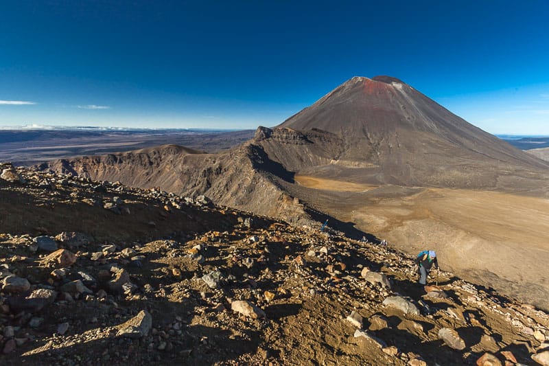
If the mountain looks familiar, it is because Peter Jackson chose this location to represent the dreaded Mount Doom in the Lord of the Rings.
What kind of hike is the Tongariro Crossing?
The Tongariro Crossing is a point-to-point hike rather than a loop, so we recommend securing a shuttle for convenience. Multiple shuttle services are available to facilitate this. We based ourselves in National Park Village and used Tongariro Crossing Shuttles.
They drop you off at one end and then pick you up upon completion. This arrangement is ideal, especially after a lengthy six-plus hours of hiking.
It is crucial to be prepared for any type of weather; once you are out on the trail, you do not want to be caught unprepared. We suggest checking the weather and volcanic activity on the Tongariro Crossing official website to stay informed before embarking on your trek.
Start of the Hike
The day commenced early as we took a shuttle from National Park Village to the starting point at Mangatepopo car park. The mornings can be quite chilly, so we bundled up for our adventure. The initial portion of the hike involves traversing stunning alpine brush at a moderate incline for about 50 minutes.
You will notice how the landscape transitions as you trek over volcanic soil, revealing the first sights of the impressive views ahead. This section of the hike is quite manageable, serving as a warm-up for the challenges to come.
Mount Doom
As you exit the alpine vegetation, you will be greeted with your first glimpse of Mount Doom. It is truly a sight to behold. However, the incline that follows is equally impressive.
This part is where the hiking becomes more challenging. The grade steepens significantly, but the views continue to improve, making the effort worthwhile. We paused for a brief rest and naturally took some photos of this iconic scene. It quickly became clear to Deb and me why this is celebrated as one of the most stunning day hikes globally.
South Crater
As we continued past Soda Springs towards the South Crater, the views of the valley below were nothing short of breathtaking. The track may be steep, ascending from about 1200 meters to 1600 meters in a relatively short distance, but the vistas make the effort well worth it.
The trail is uneven as you walk over lava flows and volcanic rocks, which certainly justifies the moniker “Devil’s Staircase.” It’s important to take your time here, capture photos, and absorb the magnificent scenery. This section provides a feeling of the North Island’s exquisite beauty, but even better views await ahead.
Red Crater
Walking along the South Crater is relatively flat and easy, but as you approach the Red Crater, it becomes quite windy, requiring some scrambling to maintain your footing. Exercise caution here, as it can be precarious if you are not attentive.
From the highest point of the Tongariro Alpine Crossing, the views of the emerald lakes, the Oturere Valley, Mt. Ruapehu, and what seems to be all of the North Island of New Zealand are simply extraordinary.
This sight will truly take your breath away. This is the moment you have been hiking for, and the reward is incredibly satisfying. We took some time to soak it in and appreciate the beauty of nature enveloping us.
Descending to the Emerald Lakes
Now, the fun begins. With the air filled with a faint smell of sulfur, we descended towards the thermal pools at a brisk pace. The loose soil allows for a kind of sliding down experience, reminiscent of our scree descent from Mount Kilimanjaro in Africa.
Just be careful, as there are steep drop-offs on each side; if you did fall, you wouldn’t stop very quickly.
The Emerald Lakes were undoubtedly the most impressive sights we encountered on this trek.
The vibrant shades of green, yellow, red, and blue are due to the minerals present in the surrounding rocks. Despite the pungent smell of sulfur here, I found it hard to look away from these natural wonders.
Blue Lake
I anticipated a continuous downhill trek after the Red Crater, but I was mistaken. The trail ascends once more as we made our way to Blue Lake, which is considered “Tapu” or sacred. No one is allowed to touch or drink from it.
After Blue Lake, most of the remarkable scenes are behind you, so remember to glance back and appreciate the views from every angle.
Ketetahi Car Park and Shelter
As the hike nears its conclusion, the scenery remains stunning. On the descent to the car park, we frequently turned back to admire the trail we had just traversed.
We observed steam rising from the Te Maari Crater, reminding us that this is still an active volcano. Indeed, you will notice numerous signs along this segment of the trail highlighting this fact. The vegetation changes as you descend, becoming even boggy, so it is essential to stay on the designated paths.
The End of the Hike
The final 30 minutes of the hike may become a bit uneventful, and fatigue is likely to set in. An optional short track branches off from the main one, leading to a waterfall, if you still have the energy to explore. However, we hurried along as we were quite tired and eager to return to the parking lot for the shuttle.
Undoubtedly, the Tongariro Crossing was one of the most remarkable day hikes we have ever undertaken.
The weather was exceptional, the views unforgettable, and the overall adventure level was high. The Tongariro Alpine Crossing genuinely stood out as the highlight of our experiences on the North Island of New Zealand.
Tongariro Crossing Facts:
How Long is the Tongariro Alpine Crossing?
The Tongariro Crossing is a 19.4km point-to-point hike.
How long does it take to hike the Tongariro Crossing?
Most hikers complete the track in 6-8 hours. This varies depending solely on individual fitness levels.
How difficult is the Tongariro Alpine Crossing?
I classify this hike as strenuous. The elevation gain is 760m, featuring several very steep sections.
Where does the Tongariro Alpine Crossing Start?
The most common starting point is at the Mangatepopo car park, located 16km from National Park Village on the North Island of New Zealand.


